

Last month we ran the Pony Express Fun Run at Camp Floyd, and had so much fun learning about the history of the Pony Express, that we decided to experience history by retracing the steps of the Pony Express riders.
Read more about Rock Collecting in Utah’s West desert HERE.
We did this adventure all in one day, without hurrying. From our home in the west part of Salt Lake City, it’s about 200 miles round-trip.
We left our Salt Lake home around 11am, and we were back home around 6pm. We stopped at every marker, and even stopped for about an hour to eat lunch. We drove a small passenger car, and had no problems maneuvering the terrain.
See map at the bottom of this post.

Before heading out to the West desert, you need to make sure you are well prepared with provisions and other necessary items. This is such a remote area, that just jumping in your vehicle and driving there isn’t going to cut it. Here are some tips when going on this adventure:
- Leave an itinerary outline and map with somebody at home, and tell them what time you are expected back. (See map at bottom of post.) There is no cell service in this area. Anything can happen when you get out in the West desert, and you want to make sure somebody knows where you are in case you need to be “rescued”.
- Have plenty of high-protein food and water. If something happens and you get stranded overnight, you want to be prepared. Make sure you also bring blankets, as it can get cold out there at night any time of the year.
- Bring toilet paper and garbage sacks. There are few bathrooms on this route, and you need to be prepared just in case you “have to go” in between restroom spots.
- Check the following items on your vehicle before leaving. (You can also call or stop by to see our friends at Gines Auto Service and they can help you check them before leaving):
- Spare tire: Make sure you have a spare tire, and that it’s properly inflated. It’s very frustrating when you have a flat tire, only to find that your spare is flat too.
- Tire jack: Make sure that you have a properly working tire jack for your specific vehicle. There are a lot of sharp rocks out there, and you need to be prepared to change a tire if you get a flat. Also, make sure you know how to change your tire and work your tire jack.
- Tire Pressure and Tread: Make sure your tires are properly inflated, and your tread isn’t worn out, to help prevent a blowout. To check your tread, you can use the “nickel trick”: Insert a nickel into the tread of the tire. If you can see the top of George Washington’s head, then your tread is too worn out and you should replace your tires.
- Check your fluids: Oil, antifreeze, windshield washer fluid, radiator fluid, etc.
What To See On This Adventure:
Head through Tooele and go South, out of Tooele, and into Stockton. You will be on Hwy 36. (Make sure to fill up on gas before leaving Tooele, because this is the last gas station you will see on this adventure.)

When you come into Stockton, watch on your right for a sign that says “Cemetery”. Turn right down that road, and the old Stockton Jail will be on your right hand side. You can’t miss it.
The old historical Stockton Jail doesn’t have much history written on it, so it’s hard to say what went on here, or who was imprisoned here. It was built in 1902, and is one of the only remaining structures still standing from that time period.
Get back on the main road before turning off to the Stockton Jail (Hwy 36), and turn right to continue on your adventure.

2. Steptoe’s Military Camp, Godbe’s Chicago Ore Smelter, and Overland Stage Station
After you leave Stockton heading South, watch for Steptoe’s Military camp on your right.
On September 2, 1854, a detachment of the U.S. Army, under the direction of Col. E.J. Steptoe, camped here. They erected quarters, stables and corrals. They also stored 200 tons of hay for their 450 mules and 300 horses. The detachment left for California in early April 1855.
An Overland Stage station also operated here from 1868 to the early 1870s.
In 1871, William S. Godbe erected a Chicago Ore smelter, and operated until about 1880. The area was then known as Slagtown.
The present line of the Union Pacific Railroad reached here in 1902.
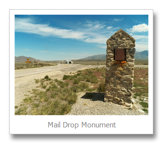
Watch on your left for the turnoff to Ophir and Mercur. Do not take that road (Hwy 73), but at the junction there is a historical marker with a mailbox in it. This is the Mail Drop Monument.
During the late 1800s this spot was a convenient mail drop for residents in Tooele and Lehi, and points in between, like Ophir and Mercur. The mailman from Tooele would collect post from there, Stockton, etc., and take it to this mail drop for pickup or delivery. The mailman from Lehi did the same thing for Ophir and Mercur.
Many people think this is a Pony Express stop, but it is not. The Pony Express route was further South, and did not come this far North.

4. William Ajax Underground Store
Continue South on Hwy 36, and watch on your Left for another historical marker. It will be before Faust, so if you come to Faust, you passed it. This is the spot where the William Ajax Underground Store was located and operated from 1870 to 1914. William Ajax built this entire store with just a shovel and a wheelbarrow. It was a two-story store, located entirely underground. Patrons from nearby farms, ranches and mines found a wide variety of merchandise, food, clothing, housewares, hardware, tools and medicines.
The surrounding area was originally called Centre, but was renamed Ajax in honor of the successful store.

Continue South on Hwy 36, and watch for a historical marker on the right side just as you come into Faust. This is the Faust Pony Express Station. (From this point on, you will be traveling the Pony Express Route.)
Henry J. Faust, a native of Germany, operated this station in 1860 as a stage manager and part-time Pony Express rider.
This is a great stop to read about the history of the Pony Express. There are multiple markers here that tell the story and tragedy of the Pony Express and its riders.

6. Last Chance Lakes Resort
After turning onto the road leading to Simpson Springs, watch on your left side for a newer housing development and gated community. This is the Last Chance Lakes Resort. It is rumored that Michael Jordan built him a house here, but that can’t be confirmed. The lake in the middle of the development is manmade, and provides many hours of water fun for the residents that live in the middle of the West Desert.

The next stop you will come to is Lookout Pass. Make sure you get out and sign the Visitor Log.
It is said the name is derived from a tale that a Pony Express rider racing east told the Express Rider heading west as they passed each other to "look out" for hostile Indians as he had just escaped from an ambush attempt.
There is also a marker here dedicated to Ray E. Staley. He was one of the pioneers of the sheep industry in the west desert.


After leaving Lookout Pass, continue down the mountain. Watch for a sign that says “Pet Cemetery” pointing left, and “Lookout Pass Station” to the right. The Lookout Pass Station was another stop for the Pony Express riders.
To go to Aunt Libby’s Pet Cemetery, turn left. The Tooele County website explains the history of the Cemetery:
From 1866 to 1900, Aunt Libby Rockwell and her husband, Horace, ran an Overland Stage Station near the summit of Lookout Pass. Since Aunt Libby had no children, she filled the void with pet dogs and cats. As her cherished pets died over the years, she located this site as their final resting place alongside three human graves, which consist of two adults and one child. Horace Rockwell was a brother to the famous Porter Rockwell.
Get back on the main road you were traveling on, and continue on to Simpson Springs.

The Simpson Springs Pony Express Station was one of the most prominent stations in the west desert. Here, riders would have access to water, food and provisions, and were able to exchange their horses for a well-rested one. This was a fun stop for us to see because when we ran the Pony Express Fun Run last month at Camp Floyd, they had a stop where we traded our horse.
This is where we chose to stop and eat lunch. There is a beautiful campground nearby, as well as restrooms.
At this stop, there are more plaques where you can learn a lot about the area, and the Pony Express and its riders. We enjoyed touring the little building, and was amazed that because of the way it was built, it stayed fairly cool inside. This must have been a favorite stopping point for many Pony Express riders to take a break, cool off, get a cool drink of water, and maybe something to eat.


The project was abandoned and never finished.
If you drive about 1/4 mile further West, park your vehicle and walk North into the desert. Walk to your right (Eastbound) and you will find rock dugouts that were probably also used for the Pony Express riders.

10. Wild Horses
After leaving Simpson Springs, turn around and go back towards where you came from. Watch for the turnoff for Dugway, and take that road North. Along this road is where you have a good chance of seeing wild horses in the distance. Any where around the Simpson Springs area (North or West usually) is where you can spot them.

When you reach Dugway, you will see a church. Turn right, which is heading East. You are now traveling along the historic Lincoln Highway. Continue on this road, and you will reach the cute little town of Terra.


When you reach the top of the canyon just outside of Terra, there is a parking area to your right. Get out there, and you will read about the historic Lincoln Highway and Fisher Pass.
The leaders of the Lincoln Highway liked to show off Fisher Pass. They used Old Betsy, to show off the completed road. Old Betsy is the official Lincoln Highway Association car, and was a Packard painted red, white, and blue.
The monument here honors Carl Fisher, the founder of the Lincoln Highway.
13. Clover Springs Campground
Continue down the canyon, and you will see Clover Springs Campground on your right. This is a beautiful place to stop and take a break, or come back another day and camp for the weekend.
Continue out of the canyon, and soon you will return to Hwy 36. Take a left turn, heading north, which will take you back to Stockton and Tooele.
Map
For this adventure, you will want to pick up a road map from a gas station. Google Maps does not have the detail needed for this adventure.
This adventure begins in Tooele on Hwy 36, traveling South through Stockton, and to Faust. When you get to Faust, you will turn right onto the Pony Express Route and Country Byway. Continue on this road to Simpson Springs, then back to the turnoff for Dugway, which is Hwy 196. When you reach Dugway, you are going to turn right and travel on Hwy 199. Continue until you reach Hwy 36 again, and turn northbound, which is left, to get back to Tooele.


Thanks for the post. I really want to go to Fish Springs sometime. Do you feel like you might not had enough gas to make it there and back to a gas station? Is there better ways to plan it or do you really need to bring extra gas in your car?
ReplyDeleteWhen my brothers and dad go duck hunting there, they always take an extra 5 gallon tank of gasoline, just to be safe. I THINK you can get there from I-80, take the Iosepa exit, head South, and in from that way.
DeleteMy brother also went to Death Canyon, which is South of Fish Springs. He said it was really cool, with a lot of old abandoned mines.
DeleteSo it looks like it is 98 miles from Tooele to Fish Springs so that is not too bad considering my car usually gets about 300 miles per fill up.
ReplyDeleteLast Monday, we drove my truck, which gets about 12-15 miles/gallon. We filled up in West Valley, drove out to Simpson Springs, then drove the extra 25 miles to the geode beds. We then drove all the way back home, and had 1/4 tank of gas left. My truck is approximately 15 gallon tank. I think Fish Springs is another 50 miles from the geode beds. We saw a LOT of people with flat tires, so make sure your spare is not flat, and you have a good jack!
DeleteDoes anyone here know if you can drive through Dugway as a civilian?
ReplyDelete